|
Lesson 1 Clouds
 
Clouds are made up of millions of tiny drops of water. They form
in different shapes and at different heights in the sky. A cloud forms
when moist air rises upwards. As the air cools, it expands and changes,
and condenses into tiny water droplets. The highest clouds contain ice crystals.
There are 3 types of HIGH CLOUDS
CIRRUS CLOUDS-
Thin wispy streaks
CIRROSTRATUS CLOUDS- Pale high
layer
CIRROCUMULUS CLOUDS-
Tiny lumps that look like bead or pearls
There are 3 types of MIDDLE CLOUD LAYER
MID LEVEL CLOUDS
ALTOCUMULUS CLOUDS- Higher lumpy
layer
ALTOSTRATUS CLOUDS- Pale white
layer
NIMBOSTRATUS CLOUDS- Grey
layer that produces rain or snow
There are 4 types of LOWEST CLOUDS
CUMULONIMBUS CLOUDS- the dark storm
clouds
CUMULUS CLOUDS- Cotton wool type
STRATOCUMULUS CLOUDS- Uneven
patchy layer
STRATUS CLOUDS- Covers top of
mountain/hills
Can you find the pictures of these clouds in your
Pocket Science Book ?

ENSO Basics
El Niño-Southern Oscillation, or ENSO for
short. Often the term ENSO Warm Phase is used to describe El Niño and
ENSO Cold Phase to describe La Niña.
What are El Niño and La Niña?
What is ENSO?
Why do we care about El Niño and La
Niña?
What are El Niño and La Niña?
The term El Niño was first coined more than 100 years ago
to describe the unusually warm waters that would occasionally form along the
coast of Ecuador and Peru. This phenomenon typically occurred late in the
calendar year near Christmas, hence the name El Niño (spanish for "the boy
child", referring to the Christ child). Today the term El Niño is used to refer
to a much broader scale phenomenon associated with unusually warm water that
occasionally forms across much of the tropical eastern and central Pacific. The
time between successive El Niño events is irregular but they typically tend to
recur every 3 to 7 years.
La Niña is the counterpart to El Niño and is characterized
by cooler than normal SSTs across much of the equatorial eastern and central
Pacific. A La Niña event often, but not always, follows an El Niño and vice
versa. Once developed, both El Niño and La Niña events tend to last for roughly
a year although occasionally they may persist for 18 months or more. El Niño
and La Niña are both a normal part of the earth's climate and there is recorded
evidence of their having occurred for hundreds of years.
Although El Niño and La Niña events are characterized by warmer or cooler than
average sea surface temperatures in the tropical Pacific, they are also
associated with changes in wind, pressure, and rainfall patterns. In the tropics
where El Niño and La Niña form, rainfall tends to occur over areas having the
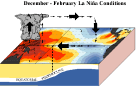
warmest sea surface temperature. The
Figure 2 below shows a schematic view of
the links between sea-surface temperatures and tropical rainfall:
-
Normal
conditions
(top-most figure below). The warmest water is found in the western Pacific,
as is the greatest rainfall. Winds near the ocean surface travel from east
to west across the Pacific (these winds are called easterlies ).
-
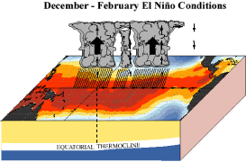
El
Niño conditions
(lower-left figure). The easterlies weaken, warmer than average sea surface
temperatures cover the central and eastern tropical Pacific, and the region
of heaviest rainfall moves eastward as well.
-
La
Niña conditions
(lower-right figure). Could be thought of as an enhancement of normal
conditions. During these events, the easterlies strengthen, colder than
average ocean water extends westward to the central Pacific, and the warmer
than average sea-surface temperatures in the western Pacific are accompanied
by heavier than usual rainfall.
·
Why do we care about El Niño and La Niña?
·
Once developed, El Niño and La Niña events typically persist for about a year
and so the shifted rainfall patterns associated with them typically persist for
several seasons as well. This can have a significant impact on people living in
areas of the tropical Pacific since the usual precipitation patterns can be
greatly disrupted by either excessively wet or dry conditions. In addition, the
shifting of tropical rainfall patterns during El Niño and La Niña not only
affects the tropical Pacific region but areas away from the tropical Pacific as
well. This includes many tropical locations as well as some regions outside the
tropics in both the Northern and Southern Hemispheres. For information about why
this happens, see the
ENSO and Climate section.
·
Seasonal climate forecasts made possible
·
The persistence of tropical sea surface temperature (and rainfall) patterns
(such as those associated El Niño and La Niña) plays a fundamental role in
making seasonal (3-month) climate forecasts possible. In the absence of El Niño
and La Niña, seasonal climate forecasts are still possible because unusually
warm or cold sea surface temperatures in other parts of the tropics can still
occur. For more details on seasonal climate forecasts, see
Forecasting Climate
EL NINO
What is an El
Niño?
What causes it?
Usually, the wind blows strongly from east
to west along the equator in the Pacific. This actually piles up water
(about half a meter's worth) in the western part of the Pacific. In the
eastern part, deeper water (which is colder than the sun-warmed surface
water) gets pulled up from below to replace the water pushed west. So, the
normal situation is warm water (about 30 C) in the west, cold (about 22 C)
in the east.
In an El Niño, the winds pushing that
water around get weaker. As a result, some of the warm water piled up in the
west slumps back down to the east, and not as much cold water gets pulled up
from below. Both these tend to make the water in the eastern Pacific
warmer, which is one of the hallmarks of an El Niño.
But it doesn't stop there. The warmer
ocean then affects the winds--it makes the winds weaker! So if the winds get
weaker, then the ocean gets warmer, which makes the winds get weaker, which
makes the ocean get warmer ... this is called a positive feedback,
and is what makes an El Niño grow.
So what makes it stop growing?
The ocean is full of waves, but you might
not know how many kinds of waves there are. There's one called a Rossby
wave that is quite unlike the waves you see when you visit the beach.
It's more like a distant cousin to a tidal wave. The difference is that a
tidal wave goes very quickly, with all the water moving pretty much in the
same direction. In a Rossby wave, the upper part of the ocean, say the top
100 meters or so, will be lesirely sliding one way, while the lower part,
starting at 100 meters and going on down, will be slowly moving the other
way. After a while they switch directions. Everything happens very slowly
and inside the ocean, and you can't even see them on the surface. These
things are so slow, they can take months or years to cross the oceans. If
you had the patience to sit there while one was going by, you'd hardly
notice it; the water would be moving 100 times slower than walking speed.
But they are large, hundreds or thousands of kilometers in length (not
height! Remember, you can hardly see them on the surface), so they can have
an effect on things. Another wave you rarely hear about is called a
Kelvin wave, and it has some characteristics in common with Rossby
waves, but is somewhat faster and can only exist close to the equator (say,
within about 5 degrees of latitude around the equator).
El Ninos often start with a Kelvin wave
propagating from the western Pacific over towards South America. Perhaps you
saw, on the TV news,
the movie (produced by JPL) for
the El Nino of 1997/98? It showed a whitish blob (indicating a sea level
some centimeters higher than usual) moving along the equator from Australia
to South America. That's one of the hallmarks of a Kelvin wave, the early
part of the El Nino process.
When an El Niño gets going in the middle
or eastern part of the Pacific, it creates Rossby waves that drift slowly
towards southeast Asia. After several months of travelling, they finally get
near the coast and reflect back. The changes in interior ocean temperature
that these waves carry with it "cancel out" the original temperature changes
that made the El Niño in the first place. I'm being deliberately vague here
becuase it's complicated; look at the "For
Further Reading" link or the "More
Technical Explanation" link
for more information. The main point is that it shuts off when the these
funny interior-ocean waves travel all the way over to the coast of Asia, get
reflected, and travel back, a process that can take many months.
What effects does it have?
A strong El Niño is often associated with
wet winters over the southeastern US, as well as drought in Indonesia and
Australia. Keep in mind that you aren't guaranteed these effects even though
there is an El Niño going on; but the El Niño does make these effects more
likely to happen.
How long does it last?
A strong El Niño can last a year or more
before conditions return to normal. If you read the bit above about Rossby
and Kelvin waves (you did, didn't you?) then you know that it lasts more or
less as long as it takes the interior-ocean waves to travel all the way over
to the coast of Asia, get reflected, and travel back. You can also look at
the
Historical El Niño
section, which has a plot showing the last 30 years of El Niños, and judge
for yourself.
How often do we get them?
El Niños happen irregularly, but if you
want to impress people at cocktail parties, you might mention that we
usually get one every three to seven years. Note the word "usually":
sometimes they turn up more frequently, sometimes less. You can also look at
the
Historical El Niño
section, which has a plot showing the last 30 years of El Niños, and judge
for yourself (deja vu).
How well can we predict El Niño?
On average,
complex computer models
designed to predict El Niño can successfully do so 12 to 18 months in
advance. However, it seems to vary by episode; sometimes El Niños are
predicted quite well, with plenty of advance notice from the models, while
other times they are predicted poorly, with the models not picking them up
until the El Niño has already started. Trying to fix up the models is one of
our research topics here at Scripps.
LA NINA
·
What is La Niña?
·
A La Niña effect may be defined as a drop in average sea-surface temperatures to
more than 0.4 degrees C (0.7 degrees F) below normal, lasting at least six
months, across a specified part of the eastern tropical Pacific (5 N- 5 S
latitude, 120-170 W longitude).
·
When La Niña forms, the hurricane season is affected as the cooling water
creates dramatic changes in the upper-level air currents that play a major role
in storm development.
·
Though El Niño caused worldwide weather problems, it also snuffed out
hurricanes. Winds 35,000 to 45,000 feet in the atmosphere shifted to come from
the west, basically shearing the tops from developing storms.
·
During La Niña, high-level westerly winds either weaken or shift to come from
the east, allowing more storms to develop, said Jerry Jarrel, director of the
National Hurricane Center in Miami.
·
The 1995 and 1996 hurricane seasons, sandwiching the last La Niña, were the most
active back-to-back seasons on record, combining for 20 hurricanes, said
Christopher Landsea with the Hurricane Research Division of the National
Oceanographic and Atmospheric Administration.
·
In 1957, 1965 and 1991, El Niños disappeared rapidly without La Niñas forming.
However, in 1969, 1972 and 1987, La Niñas were in place by July.
·
Even if it is too late to affect a hurricane season, La Niña can have a profound
impact on fall and winter weather in Florida and the United States. During one,
Florida can expect winter - already a dry season - to be warmer and drier.
·
``It will be drier with fewer cold fronts and more sunshine,'' Landsea said.
``Four or five months with no rain could have a dramatic effect on the potential
for fires.''
·
Some cold fronts still could wander into the state even if temperatures are
warmer on average, as expected, Kousky said. ``There will be a lot more
variability this winter. Chances are you will experience some colder periods
than you had last year.''
·
The northern part of the country can expect a colder winter, he added, while the
Midwest can expect less rain or snow. Droughts struck that region in 1988-89 and
1995-96 following La Niñas.
·
``It accentuates the normal pattern,'' Kousky said. ``Areas that are cold will
be colder. Areas that are warm will be warmer.''
·
La Niña conditions may persist for as long as two years.
·
Frequently asked questions
·
What's the difference between La Niña
and El Niño?
Both terms refer to large-scale changes in sea-surface temperature across the
eastern tropical Pacific. Usually, sea-surface readings off South America's west
coast range from the 60s to 70s F, while they exceed 80 degrees F in the "warm
pool" located in the central and western Pacific.
·
This warm pool expands to cover the tropics during El Niño, but during La Niña,
the easterly trade winds strengthen, cold upwelling off Peru and Ecuador
intensifies, and sea-surface temperatures there fall as much as 7 degrees F
below normal. Like its counterpart, La Niña tends to peak during the Northern
Hemisphere winter. El Niños were present 31% of the time and La Niñas 23% of the
time from 1950 to 1997.
·
What are La Niña's main weather and
climate impacts worldwide and across the United States?
In many locations, especially in the tropics, La Niña produces the opposite
kinds of climate variations from El Niño.
·
For instance, parts of Australia and Indonesia are prone to drought during El
Niño but are typically wetter than normal during La Niña. However, there are
also more complex U.S. effects due to the influence of the North Atlantic
oscillation and other climate variables.
·
Hurricanes:
Hurricanes are more likely to form across the Atlantic Ocean and Gulf of Mexico
during La Niña than El Niño. In fact, the Atlantic's two busiest back-to-back
seasons on record -- 1995 and 1996 -- occurred on either side of the last La
Niña.
·
Tornadoes:
Despite the intense, frequent tornadoes during this past El Niño spring across
the South and East, some research has shown that outbreaks of violent tornadoes
east of the Mississippi River are actually more likely during springs that
follow La Niña. Examples include the Jumbo Outbreak of April 3-4, 1974, which
produced a record 148 tornadoes; the Palm Sunday tornadoes of 1965; and the 76
killer tornadoes (a record) that occurred in 1909.
·
Precipitation:
The southern and central United States tend to be drier than normal during a La
Niña winter. Major droughts accompanied the last two La Niñas in the Midwest
(1988-89) and southern plains (1995-96). The Pacific Northwest tends to be
wetter during La Niña than El Niño.
·
Temperature:
On average, north-south temperature contrasts are increased during La Niña
winters. Cooler than normal conditions become more likely across the Northwest
and warmer than normal conditions across the South and East.
·
Why haven't we heard much about La
Niña before now?
Partly because La Niña's effects on the immediate coast of South America are
benign rather than destructive, the phenomenon wasn't recognized until much
later than El Niño.
·
Research on La Niña (Spanish for "the girl") began only after the phenomenon was
recognized and named in the 1980s. It is also called El Viejo ("the old man") or
the anti-El Niño.
·
When have La Niñas occurred?
The answer varies depending on the definition used.
·
According to the National Centers for Environmental Prediction, this century's
previous La Niñas began in 1904, 1908, 1910, 1916, 1924, 1928, 1938, 1950, 1955,
1964, 1970, 1973, 1975, 1988, and 1995. These events typically continued into
the following spring. Since 1975, La Niñas have been only half as frequent as El
Niños.

Lesson 2 Rainbows
After a rain showers, the
sunlight or daylight from the sun shines through the clouds. The sunlight
then reflect off millions of water raindrop like a mirror splitting the
sun's white lights into rays of different colours - in this
order- 7 different colours
R O Y G B I V
Red,
Orange,
Yellow,
Green,
Blue,
Indigo,
Violet
Try this next time during
or after a sudden shower or rain on a sunny day, stand
with your back to the sun and look for your rainbows.
Lesson 3 World
Heritage sites
 See the pictures by
countries See the pictures by
countries
See
the list here 
Lesson 4
CONTINENTS & OCEANS
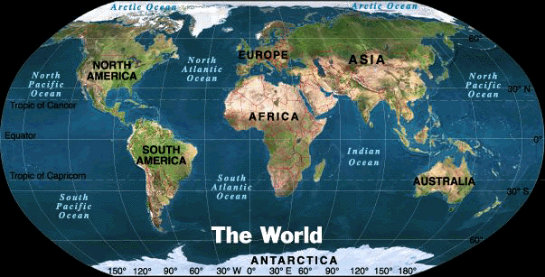
Are you ready to learn the seven continents and the major
bodies of water that surround them! Get ready to explore many different
ways to describe the location of each continent!
About the Continents
Earth is the planet that we all live on. It is shaped like a gigantic sphere or
ball. There are seven continents on the earth.
They are North America, South America, Africa, Antarctica,
Australia, Asia, and Europe.
To name the seven
continents, think of the letter a,
and when you're down to only one an "e" will save the day!
There is Africa, Antarctica, Australia,
Asia, too.
The oceans run between us, with waters deep and blue.
There is also two America's, North and
South you see,
and now you're coming to the end, Europe
starts with "E!"
The Seven Continents' song/poem will help you remember each of
these. Each continent except for Australia and Antarctica is made up of
different countries. Each country is made up of states, and each state is made
up of cities and counties. The continents are surrounded by oceans. The
largest oceans in the world are the Pacific Ocean, Atlantic Ocean, Indian Ocean,
and Arctic Ocean. These large bodies of water are located between the seven
continents.
As you explore this web site, pay close attention to the shapes
of each continent. When viewing the continents, relate the continents with
something you are familiar with to help you remember the images.
Definitions for reading maps
cardinal directions- the
directions north (N), south (S), east (E), and west (W)
compass rose- tells you
directions, or which way you need to go to get to some place
continent- one of the seven main
land areas on the earth
distance scale- a scale used to measure the distance or how
far something is between two places on a map
equator- imaginary line that is
halfway between the North Pole and the South Pole
hemisphere- means half of the earth
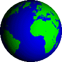
globe- a model of the Earth that shows
us where places are located on our planet
location- is where something is found
map- a flat picture or drawing of the
earth that shows us where places are located on our planet
oceans- a large body of salt water
prime meridian- the great circle which divides the earth in
half vertically creating the Eastern and Western Hemispheres
Understanding the Hemispheres
The hemispheres of the earth basically tell you what half of the earth
different land masses (Ex. seven continents) are located.
The Northern Hemisphere is the half of the earth north of
the equator, and the Southern Hemisphere is the half of the earth south of
the hemisphere.
OCEANS
EARTH'S OCEANS: An Introduction
Oceans
cover about 70% of the Earth's surface. The oceans contain roughly 97% of
the Earth's water supply.
The oceans of Earth are unique in our Solar System.
No other planet in our Solar System has liquid water (although recent finds
on Mars indicate that Mars may have had some liquid water in the recent
past). Life on Earth originated in the seas, and the oceans continue to be
home to an incredibly diverse web of life.
The oceans of Earth serve
many functions, especially affecting the weather and temperature. They
moderate the Earth's temperature by absorbing incoming solar radiation
(stored as heat energy). The always-moving ocean currents distribute this
heat energy around the globe. This heats the land and air during winter and
cools it during summer.
THE OCEANS
The Earth's oceans are all connected to one another. Until the year 2000,
there were four recognized oceans: the Pacific, Atlantic, Indian, and
Arctic. In the Spring of 2000, the International Hydrographic Organization
delimited a new ocean, the Southern Ocean (it surrounds Antarctica and
extends to 60 degrees latitude).
There are also many seas (smaller branches of an
ocean); seas are often partly enclosed by land. The largest seas are the
South China Sea, the Caribbean Sea, and the Mediterranean Sea.
| Ocean |
Area (square miles) |
Average Depth (ft) |
Deepest depth
(ft) |
| Pacific Ocean |
64,186,000 |
15,215 |
Mariana Trench, 36,200 ft deep |
| Atlantic Ocean |
33,420,000 |
12,881 |
Puerto Rico Trench, 28,231 ft
deep |
| Indian Ocean |
28,350,000 |
13,002 |
Java Trench, 25,344 ft deep |
| Southern Ocean |
7,848,300 sq. miles (20.327 million sq km
) |
13,100 - 16,400 ft deep (4,000 to 5,000
meters) |
the southern end of the South
Sandwich Trench, 23,736 ft (7,235 m) deep |
| Arctic Ocean |
5,106,000 |
3,953 |
Eurasia Basin, 17,881 ft deep |
Lesson 5 UNITED
STATES OF AMERICA
United
States Map- interactive

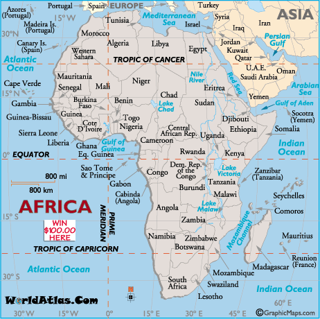
Lesson 6
AFRICA
Lesson 7 CHINA
China is the largest country
entirely in Asia. China is bordered by Russia, India, Afghanistan, Bhutan,
Myanmar, Kazakhstan, North Korea, Kyrgyzstan, Laos, Mongolia, Nepal,
Pakistan, Tajikistan, and Vietnam
RIVERS OF CHINA.
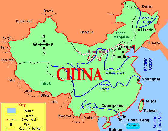
CHINESE MAP OF CHINA
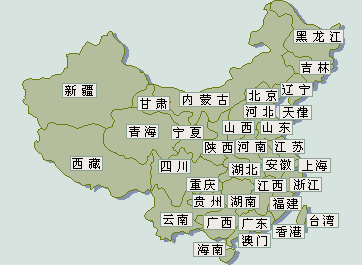
ENGLISH MAP OF CHINA

Lesson 8
TIDES & LUNAR ECLIPSE
TIDES
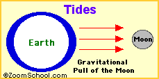
Tides are periodic rises and falls of large bodies
of water. Tides are caused by the gravitational interaction between the Earth
and the Moon.
The gravitational attraction of the moon causes
the oceans to bulge out in the direction of the moon.
Another bulge occurs on the opposite side, since
the Earth is also being pulled toward the moon (and away from the water on the
far side).
Since the earth is rotating while this is
happening, two tides occur each day.
Isaac Newton (1642 -1727) was the first person to explain tides scientifically.
His explanation of the tides (and many other phenomena) was published in 1686,
in the second volume of the Principia.
The Sun's Interaction with the Tides
Spring Tides
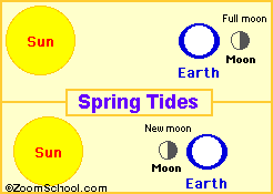
Spring tides are especially strong tides (they do not have anything to do with
the season Spring). They occur when the Earth, the Sun, and the Moon are in a
line. The gravitational forces of the Moon and the Sun both contribute to the
tides. Spring tides occur during the full moon and the new moon.
The Proxigean Spring Tide is a rare,
unusually high tide. This very high tide occurs when the moon is both unusually
close to the Earth (at its closest perigee, called the proxigee) and in the New
Moon phase (when the Moon is between the Sun and the Earth). The proxigean
spring tide occurs at most once every 1.5 years.
Neap Tides

Neap tides are especially weak tides. They occur when the gravitational forces
of the Moon and the Sun are perpendicular to one another (with respect to the
Earth). Neap tides occur during quarter moons.
LUNAR ECLIPSE
A lunar eclipse OR ECLIPSE OF THE MOON occurs when the Earth's
shadow falls on the moon. Notice the position of the EARTH in between the MOON
AND SUN -blocking it from the SUN.
Lunar eclipses occur, on average, about every 6 months.

Types of Lunar Eclipses
- Total Eclipse - When the entire moon enters the Earth's umbra (the
darkest part of its shadow), this is called a total eclipse.
- Partial Eclipse - When only part of the moon enters the Earth's umbra,
this is called a partial eclipse.
Duration of Lunar Eclipses
During an average total lunar eclipse, the moon is within the Earth's umbra for
about an hour. This is called totality.
Frequency of Lunar Eclipses
Since the plane of the moon's orbit is inclined about 5°: from the plane of the
Earth's orbit, lunar eclipses are relatively infrequent. There are about two
lunar eclipses each year (visible somewhere on Earth).
SOLAR ECLIPSE 2009
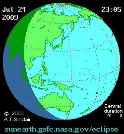
About the Eclipse
The July 22, 2009 Total Solar Eclipse in China is the
longest total solar eclipse in our lifetime, and the
second longest in recorded history, next only to the June 20,
1955 eclipse in Manila.
Totality will last 5 min 8.6 sec in Shanghai and 5 min 27.8
sec in Wuhan. In 1955 totality was 6 min 1.0 sec in Manila and 7
min 6.3 sec in San Pablo, Laguna. The 2009 eclipse will not be
surpassed in duration until June 13, 2132.
CHECK IT OUT
Lesson 9
OUTER SPACE & SOLAR SYSTEM
OUTER SPACE AND SOLAR SYSTEM
Lesson 10 TBA
|